File:Mendip Hills Map.png
Jump to navigation
Jump to search

Size of this preview: 800 × 470 pixels. Other resolutions: 320 × 188 pixels | 640 × 376 pixels | 1,024 × 602 pixels | 1,280 × 752 pixels | 2,512 × 1,476 pixels.
Original file (2,512 × 1,476 pixels, file size: 1.3 MB, MIME type: image/png)
File history
Click on a date/time to view the file as it appeared at that time.
| Date/Time | Thumbnail | Dimensions | User | Comment | |
|---|---|---|---|---|---|
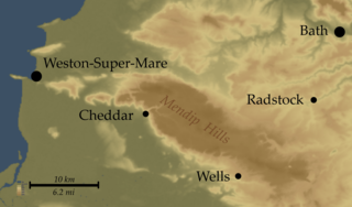
| current | 21:29, 12 March 2007 | | 2,512 × 1,476 (1.3 MB) | commons>SFC9394 | {{Information |Description= Map of Mendip Hills, England |Source=Topo data from NASA SRTM, PD |Date=12-03-07 |Author=Myself |Permission= |other_versions= }} |
File usage
There are no pages that use this file.