File:Matabeleland.svg
Jump to navigation
Jump to search

Size of this PNG preview of this SVG file: 250 × 228 pixels. Other resolutions: 263 × 240 pixels | 526 × 480 pixels | 842 × 768 pixels | 1,123 × 1,024 pixels | 2,246 × 2,048 pixels.
Original file (SVG file, nominally 250 × 228 pixels, file size: 30 KB)
File history
Click on a date/time to view the file as it appeared at that time.
| Date/Time | Thumbnail | Dimensions | User | Comment | |
|---|---|---|---|---|---|
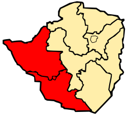
| current | 17:26, 4 March 2008 | | 250 × 228 (30 KB) | commons>Mangwanani | == Summary == {{Information |Description=Map of Zimbabwe showing Matabeleland |Source=self made |Date=3 March 2008 |Author=Mangwanani using Inkscape |Permission= |other_versions= }} == Licensing == {{PD-self}} Category:Maps of Zimbabwe |
File usage
There are no pages that use this file.