File:Mappa ferrovia Seregno-Bergamo.png
Jump to navigation
Jump to search

Size of this preview: 799 × 288 pixels. Other resolutions: 320 × 115 pixels | 640 × 231 pixels | 1,800 × 649 pixels.
Original file (1,800 × 649 pixels, file size: 2.17 MB, MIME type: image/png)
Summary
| Description |
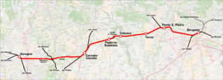
Italiano: Mappa della ferrovia Seregno–Bergamo. |
|||
| Date | (see file history) | |||
| Source | openstreetmap.org | |||
| Creator |
OpenStreetMap contributors |
|||
| Permission (Reusing this file) |
OpenStreetMap data is available under the Open Database License (details). Map tiles are licensed under the Creative Commons Attribution-ShareAlike 2.0 license (CC-BY-SA 2.0).
This file is licensed under the Creative Commons Attribution-Share Alike 2.0 Generic license.
|
|||
| Georeferencing | If inappropriate please set warp_status = skip to hide. |
| Annotations | This image is annotated: View the annotations at Commons |
File history
Click on a date/time to view the file as it appeared at that time.
| Date/Time | Thumbnail | Dimensions | User | Comment | |
|---|---|---|---|---|---|
| current | 00:25, 5 July 2017 | 1,800 × 649 (2.17 MB) | commons>Arbalete | Distinguo stazioni e fermate |
File usage
There are no pages that use this file.