File:Map of the Erivan Khanate in 1820.svg
Jump to navigation
Jump to search

Size of this PNG preview of this SVG file: 800 × 467 pixels. Other resolutions: 320 × 187 pixels | 640 × 374 pixels | 1,024 × 598 pixels | 1,280 × 747 pixels | 2,560 × 1,494 pixels | 3,748 × 2,188 pixels.
Original file (SVG file, nominally 3,748 × 2,188 pixels, file size: 2.11 MB)
File history
Click on a date/time to view the file as it appeared at that time.
| Date/Time | Thumbnail | Dimensions | User | Comment | |
|---|---|---|---|---|---|
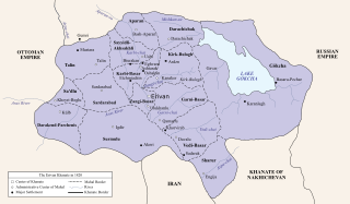
| current | 23:17, 6 May 2024 | | 3,748 × 2,188 (2.11 MB) | commons>HistoryofIran | =={{int:filedesc}}== {{Information |description={{en|1=Map of the Erivan Khanate, a province of Iran.}} |date=2024-05-07 |source=* Based on the map in Bournoutian, George (1992). The Khanate of Erevan Under Qajar Rule: 1795-1828, page 25 * Created the Nakhichevan Khanate through Bournoutian, George (1994). A History of Qarabagh: An Annotated Translation of Mirza Jamal Javanshir Qarabaghi's Tarikh-e Qarabagh, page 25 * Created the Russia border through Tsutsiev, Arthur (2014). Atlas of the Eth... |
File usage
There are no pages that use this file.