File:Map of Banstead 1841 Lambert.png
Jump to navigation
Jump to search

Size of this preview: 417 × 599 pixels. Other resolutions: 167 × 240 pixels | 334 × 480 pixels | 534 × 768 pixels | 713 × 1,024 pixels | 1,425 × 2,048 pixels | 3,231 × 4,642 pixels.
Original file (3,231 × 4,642 pixels, file size: 7.12 MB, MIME type: image/png)
File history
Click on a date/time to view the file as it appeared at that time.
| Date/Time | Thumbnail | Dimensions | User | Comment | |
|---|---|---|---|---|---|
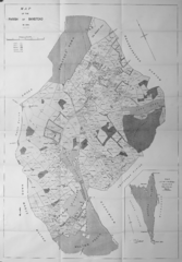
| current | 18:29, 7 March 2015 | | 3,231 × 4,642 (7.12 MB) | commons>Jmchutchinson | {{Information |Description ={{en|1=Map of Banstead in 1841 from Lambert, H.C.M. 1912 ''History of Banstead in Surrey''; the book provides annotations for some of the place names, many of which have given rise to modern street names. Two scans had to... |
File usage
There are no pages that use this file.