File:Map indicating Prince Regent Inlet, Nunavut, Canada.png
Jump to navigation
Jump to search
No higher resolution available.
Map_indicating_Prince_Regent_Inlet,_Nunavut,_Canada.png (385 × 330 pixels, file size: 56 KB, MIME type: image/png)
File history
Click on a date/time to view the file as it appeared at that time.
| Date/Time | Thumbnail | Dimensions | User | Comment | |
|---|---|---|---|---|---|
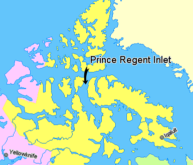
| current | 02:31, 22 March 2006 | | 385 × 330 (56 KB) | commons>David Kernow~commonswiki | == Summary == Map indicating Prince Regent Inlet, Nunavut, Canada. {{legend|#ffff66|Nunavut}} {{legend|#ffccff|Northwest Territories}} {{legend|#ffffcc|Greenland}} <br> © Her Majesty the Queen in Right of Canada, Department |
File usage
There are no pages that use this file.