File:MSP AIRPORT original boun.gif
Jump to navigation
Jump to search
Size of this preview: 646 × 599 pixels. Other resolutions: 259 × 240 pixels | 518 × 480 pixels.
Original file (800 × 742 pixels, file size: 90 KB, MIME type: image/gif)
Summary
| Description | |
| Date | 21 August 2007 (original upload date) |
| Source | Own work |
| Author | User:Myotus |
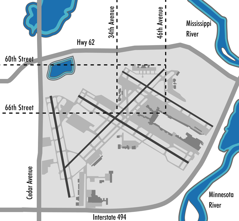
Map showing the boundaries of the original Minneapolis-St. Paul International Airport and of the Twin Cities Speedway Race track that preceded it.
Map illustration by Joe Hoover, 2007, for book: "Richfield Minnesota's Oldest Suburb" published by the Richfield Historical Society. Reproduced with permission of the artist and released to GFDL courtesy of Joe Hoover.
Licensing
User:Myotus, the copyright holder of this work, hereby publishes it under the following licenses:

|
Permission is granted to copy, distribute and/or modify this document under the terms of the GNU Free Documentation License, Version 1.2 or any later version published by the Free Software Foundation; with no Invariant Sections, no Front-Cover Texts, and no Back-Cover Texts. A copy of the license is included in the section entitled GNU Free Documentation License. |
| This file is licensed under the Creative Commons Attribution-Share Alike 3.0 Unported license. | ||
| Attribution: User:Myotus | ||
| ||
| This licensing tag was added to this file as part of the GFDL licensing update. |
This file is licensed under the Creative Commons Attribution 2.5 Generic license.
Attribution: User:Myotus
- You are free:
- to share – to copy, distribute and transmit the work
- to remix – to adapt the work
- Under the following conditions:
- attribution – You must give appropriate credit, provide a link to the license, and indicate if changes were made. You may do so in any reasonable manner, but not in any way that suggests the licensor endorses you or your use.
You may select the license of your choice.
Original upload log
Transferred from en.wikipedia to Commons using FtCG.
The original description page was here. All following user names refer to en.wikipedia.
| Date/Time | Dimensions | User | Comment |
|---|---|---|---|
| 19:10, 4 November 2007 | 800 × 742 (92,381 bytes) | w:en:Myotus (talk | contribs) | (== Summary == Map showing the boundaries of the original Minneapolis-St. Paul International Airport and of the Twin Cities Speedway Race track that preceded it. Map illustration by Joe Hoover, 2007, for book: "Richfield Minnesota's Oldest Suburb" publis) |
| 19:09, 21 August 2007 | 578 × 500 (45,542 bytes) | w:en:Myotus (talk | contribs) | (Map showing the boundaries of the original Minneapolis-St. Paul International Airport and of the Twin Cities Speedway Race track that preceded it. Map created by Joe Hoover 2007 for book: "Richfield Minnesota's Oldest Suburb" published by the Richfield ) |
File history
Click on a date/time to view the file as it appeared at that time.
| Date/Time | Thumbnail | Dimensions | User | Comment | |
|---|---|---|---|---|---|
| current | 05:29, 24 May 2012 | | 800 × 742 (90 KB) | commons>Addihockey10 | Transferred from en.wikipedia: see original upload log above |
File usage
There are no pages that use this file.