File:Level IV ecoregions, Eastern Cascades.png
Jump to navigation
Jump to search

Size of this preview: 215 × 597 pixels. Other resolutions: 86 × 240 pixels | 604 × 1,678 pixels.
Original file (604 × 1,678 pixels, file size: 748 KB, MIME type: image/png)
File history
Click on a date/time to view the file as it appeared at that time.
| Date/Time | Thumbnail | Dimensions | User | Comment | |
|---|---|---|---|---|---|
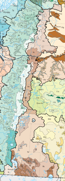
| current | 02:05, 16 June 2008 | 604 × 1,678 (748 KB) | commons>Northwest-historian | {{Information |Description={{en|1= Level IV ecoregions in the Eastern Cascades Slopes and Foothills ecoregion, as defined by the EPA. This map is a draft and may now be slightly outdated. For more information about these ecoregions, see [http://www.epa.go |
File usage
There are no pages that use this file.