File:Lebanon tectonics.png
Jump to navigation
Jump to search

Size of this preview: 516 × 600 pixels. Other resolutions: 206 × 240 pixels | 413 × 480 pixels | 661 × 768 pixels | 881 × 1,024 pixels | 1,816 × 2,111 pixels.
Original file (1,816 × 2,111 pixels, file size: 787 KB, MIME type: image/png)
File history
Click on a date/time to view the file as it appeared at that time.
| Date/Time | Thumbnail | Dimensions | User | Comment | |
|---|---|---|---|---|---|
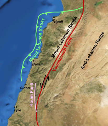
| current | 21:48, 3 March 2011 | | 1,816 × 2,111 (787 KB) | commons>Mikenorton | {{Information |Description ={{en|1=Map of the the main tectonic features in the coastal part of Lebanon, modified after Elias et al. 2007 [http://www.ipgp.fr/~klinger/page_web/biblio/publication/elias%20et%20al%20final%20proof.pdf]}} |Source ={ |
File usage
There are no pages that use this file.