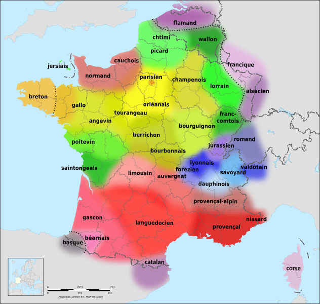
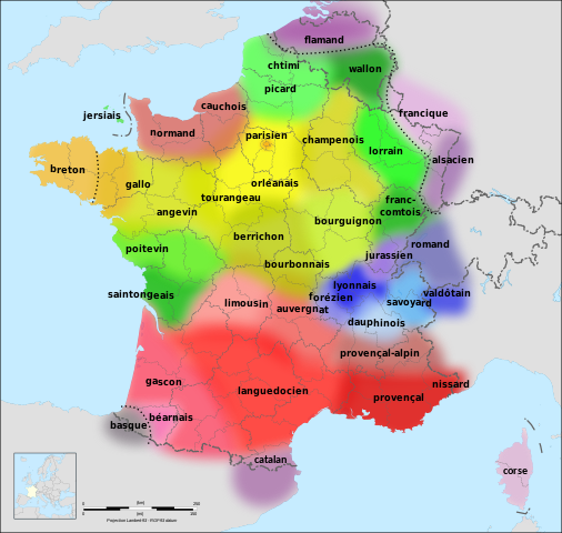
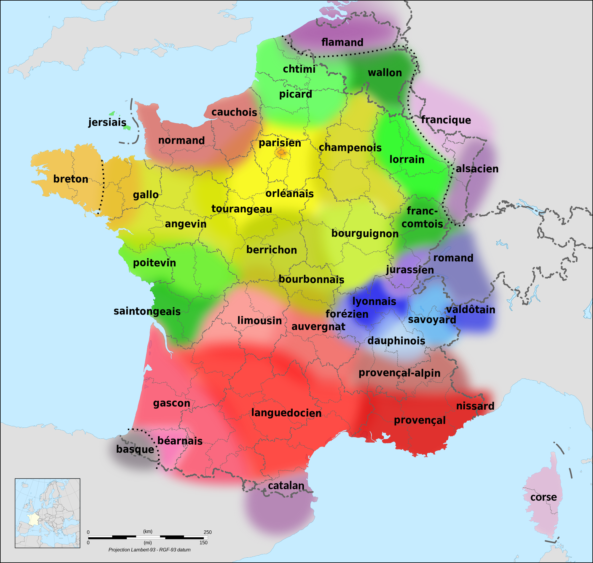
File:Langues de la France.svg
Jump to navigation
Jump to search

Size of this PNG preview of this SVG file: 632 × 600 pixels. Other resolutions: 253 × 240 pixels | 506 × 480 pixels | 809 × 768 pixels | 1,079 × 1,024 pixels | 2,158 × 2,048 pixels | 2,000 × 1,898 pixels.
Original file (SVG file, nominally 2,000 × 1,898 pixels, file size: 1.18 MB)
Summary
| Description |
|
| Date | (UTC) |
| Source | |
| Author |
|
| Other versions |
[]
|
| SVG development |


Licensing
This file is licensed under the Creative Commons Attribution-Share Alike 3.0 Unported license.
- You are free:
- to share – to copy, distribute and transmit the work
- to remix – to adapt the work
- Under the following conditions:
- attribution – You must give appropriate credit, provide a link to the license, and indicate if changes were made. You may do so in any reasonable manner, but not in any way that suggests the licensor endorses you or your use.
- share alike – If you remix, transform, or build upon the material, you must distribute your contributions under the same or compatible license as the original.
Original upload log
This image is a derivative work of the following images:
- File:Langues de la France1.gif licensed with Attribution
- 2009-11-11T07:57:53Z Parigot 603x599 (178168 Bytes) Colorisation du saintongeais.
- 2008-01-21T20:48:21Z Parigot 603x599 (179774 Bytes) Finalisation des retouches géo-linguistiques
- 2008-01-21T20:35:50Z Parigot 603x599 (179708 Bytes) {{Information |Description= |Source= |Date= |Author= |Permission= |other_versions= }}
- 2008-01-21T20:31:20Z Parigot 603x599 (179708 Bytes) Modification poitevin et saintongeais
- 2008-01-21T20:22:56Z Parigot 603x599 (179683 Bytes) Modification des limites linguistiques poitevine et saintongeaise.
- 2008-01-20T18:38:48Z Parigot 603x599 (179753 Bytes) Carte des langues régionales.
- 2007-08-12T10:05:05Z Parigot 654x650 (123918 Bytes) Nouvelle version fichier image. Ajout parler angevin
- 2007-08-12T10:02:48Z Parigot 654x650 (123918 Bytes) Nouvelle version du fichier avec ajout du parler angevin
- 2007-08-12T10:02:05Z Parigot 654x650 (123918 Bytes) Nouvelle version du fichier avec ajout du parler angevin
- 2007-08-12T09:58:26Z Parigot 654x650 (123918 Bytes) Nouvelle version du fichier avec ajout du parler angevin
- 2006-11-30T12:19:15Z Yug 654x650 (37578 Bytes) improved : Occitan => Languedocien
- 2006-11-18T02:26:22Z Chlämens 654x650 (38730 Bytes)
- 2006-07-27T12:53:36Z Moyogo 654x650 (37081 Bytes) removed québécois - title says 'Languages of France'.
- 2005-04-03T11:12:50Z Chlämens 654x650 (46252 Bytes)
- File:Départements de France-simple.svg licensed with PD-self
- 2007-09-09T11:49:17Z Marmelad 507x553 (148302 Bytes) added a box zoomed in around Paris to show the small departements near the city, as in [[:Image:Carte France Département 95.png]] (currently hidden). For documentation on how to use this image, see [[:User:Marmelad/FRA-Map
- 2007-09-08T17:06:31Z Marmelad 507x553 (147117 Bytes) Cleaned up the svg code for use with auto-generating software.
- 2007-04-24T09:27:36Z Emmanuel.boutet 507x553 (184098 Bytes) {{Information |Description=Version simplifiée de [[:Image:Départements et régions de France.svg]] |Source=[[:Image:Départements et régions de France.svg]] by [[User:bayo|bayo]] |Date=2007-04-24 |Author=[[User:Emmanuel.bo
- File:France map Lambert-93 with regions and departments-blank.svg licensed with PD-self
- 2008-11-13T19:38:00Z by Sting 2000×1898 (865 Kio)
Uploaded with derivativeFX
File history
Click on a date/time to view the file as it appeared at that time.
| Date/Time | Thumbnail | Dimensions | User | Comment | |
|---|---|---|---|---|---|
| current | 14:18, 22 February 2022 | | 2,000 × 1,898 (1.18 MB) | commons>Eowyn Cwper | Added language family separator; minor label improvements and corrections |
File usage
There are no pages that use this file.