File:Kayseri districts.png
Jump to navigation
Jump to search

Size of this preview: 729 × 600 pixels. Other resolutions: 292 × 240 pixels | 583 × 480 pixels | 999 × 822 pixels.
Original file (999 × 822 pixels, file size: 51 KB, MIME type: image/png)
Summary
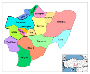
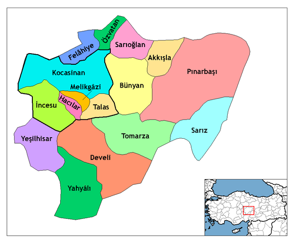
| Description | Map of the districts of Kayseri province in Turkey. Created by Rarelibra 21:59, 1 December 2006 (UTC) for public domain use, using MapInfo Professional v8.5 and various mapping resources. Edited by One Homo Sapiens Corrected text where İ, Ş, ı, ğ, or ş occurs in name. Source: [statoids-com]. Increased font size and enhanced color differences among adjacent districts. User:Sae1962 Marked the boundaries of the provincial centre, the city of Kayseri, with bold lines. |
| Date | 1 December 2006 (original upload date) |
| Source | No machine-readable source provided. Own work assumed (based on copyright claims). |
| Author | No machine-readable author provided. Rarelibra assumed (based on copyright claims). |
Licensing
| I, the copyright holder of this work, release this work into the public domain. This applies worldwide. In some countries this may not be legally possible; if so: I grant anyone the right to use this work for any purpose, without any conditions, unless such conditions are required by law. |
File history
Click on a date/time to view the file as it appeared at that time.
| Date/Time | Thumbnail | Dimensions | User | Comment | |
|---|---|---|---|---|---|
| current | 11:25, 30 July 2009 | | 999 × 822 (51 KB) | commons>Sae1962 | {{Information |Description=Map of the districts of Kayseri province in Turkey. Created by Rarelibra 21:59, 1 December 2006 (UTC) for public domain use, using MapInfo Professional v8.5 and various mapping resources. Edited by [[User:One |
File usage
There are no pages that use this file.