File:Halle (Westfalen) - land utilization.svg
Jump to navigation
Jump to search

Size of this PNG preview of this SVG file: 668 × 599 pixels. Other resolutions: 268 × 240 pixels | 535 × 480 pixels | 856 × 768 pixels | 1,142 × 1,024 pixels | 2,283 × 2,048 pixels | 1,020 × 915 pixels.
Original file (SVG file, nominally 1,020 × 915 pixels, file size: 541 KB)
_-_land_utilization.svg)
| Description |
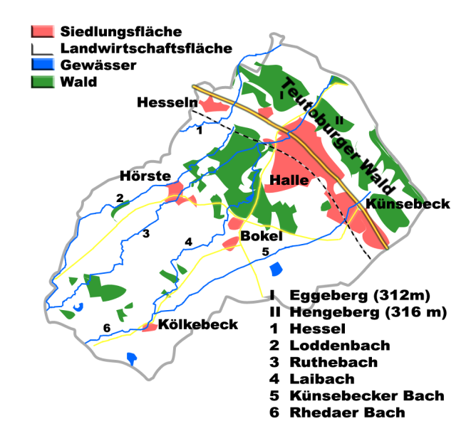
English: Land utilization in Halle (Westfalen), County of Gütersloh, Germany
Deutsch: Flächennutzung Halle (Westfalen), Kreis Gütersloh, Deutschland |
| Date | |
| Source | Own work |
| Author | Hagar66 |
| Camera location | | View this and other nearby images on: OpenStreetMap |
|---|
_-_land_utilization.svg¶ms=052.060833_N_0008.359722_E_globe:Earth_type:camera__&language=en)
Homemade maps cannot be 100% accurate. This is especially true for topographical data that is hard to incorporate 100% correctly in such maps. You are free to use the map as a starting point for your new improved versions.
Licensing
| I, the copyright holder of this work, release this work into the public domain. This applies worldwide. In some countries this may not be legally possible; if so: I grant anyone the right to use this work for any purpose, without any conditions, unless such conditions are required by law. |
File history
Click on a date/time to view the file as it appeared at that time.
| Date/Time | Thumbnail | Dimensions | User | Comment | |
|---|---|---|---|---|---|
| current | 20:32, 26 April 2009 | | 1,020 × 915 (541 KB) | commons>Hagar66 | {{Information |Description= |Source= |Date= |Author= |Permission= |other_versions= }} |
File usage
There are no pages that use this file.
_-_land_utilization.svg)