File:Hale Bridge.jpg
Jump to navigation
Jump to search

Size of this preview: 749 × 599 pixels. Other resolutions: 300 × 240 pixels | 600 × 480 pixels | 960 × 768 pixels | 1,280 × 1,024 pixels | 2,560 × 2,048 pixels | 4,314 × 3,452 pixels.
Original file (4,314 × 3,452 pixels, file size: 892 KB, MIME type: image/jpeg)
|
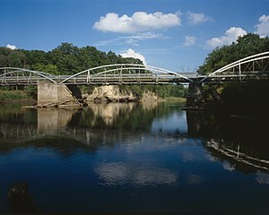
This is an image of a place or building that is listed on the National Register of Historic Places in the United States of America. Its reference number is 98000539. |
| Camera location | | View this and other nearby images on: OpenStreetMap |
|---|
| Description |
English: Western (upsteam) side of the Hale Bridge, which carries 100th Street over the Wapsipinicon River west of Oxford Junction in Hale Township, Jones County, Iowa, United States. Built in 1877, the bowstring through arch truss bridge is listed on the National Register of Historic Places. |
||||
| Date | Summer 1995 | ||||
| Source | Library of Congress, Prints and Photograph Division HAER: IA-59-14 | ||||
| Author | Joseph Elliott | ||||
| Permission (Reusing this file) |
|
||||
| Other versions |
|


|
This image is available from the United States Library of Congress's Prints and Photographs division
under the digital ID hhh.ia0435. This tag does not indicate the copyright status of the attached work. A normal copyright tag is still required. See Commons:Licensing.
|
File history
Click on a date/time to view the file as it appeared at that time.
| Date/Time | Thumbnail | Dimensions | User | Comment | |
|---|---|---|---|---|---|
| current | 21:50, 31 May 2009 | | 4,314 × 3,452 (892 KB) | commons>Cropbot | upload cropped version, operated by User:Finavon. Summary: border cropped |
File usage
There are no pages that use this file.