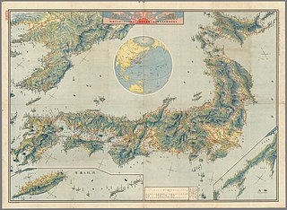
File:Empire-of-Japan-Topographic-Map-大日本帝国の地形図-1918.jpg
Jump to navigation
Jump to search

Size of this preview: 800 × 585 pixels. Other resolutions: 320 × 234 pixels | 640 × 468 pixels | 1,024 × 749 pixels | 1,280 × 936 pixels | 2,560 × 1,871 pixels | 8,922 × 6,522 pixels.
Original file (8,922 × 6,522 pixels, file size: 23.47 MB, MIME type: image/jpeg)
File history
Click on a date/time to view the file as it appeared at that time.
| Date/Time | Thumbnail | Dimensions | User | Comment | |
|---|---|---|---|---|---|
| current | 14:59, 14 May 2021 | | 8,922 × 6,522 (23.47 MB) | commons>Artanisen | Uploaded a work by Asahi Shimbun from https://web.archive.org/web/20210514141905/https://www.mapmania.org/map/86749/1915_map_of_japan_korea__taiwan with UploadWizard |
File usage
There are no pages that use this file.