File:Edward Jollie.jpg
Edward_Jollie.jpg (182 × 228 pixels, file size: 8 KB, MIME type: image/jpeg)
Summary
| Description |
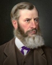
English: Edward Jollie was the Surveyor who laid out the township of Lyttelton and the city of Christchurch in 1849-50. |
||||||||||||||||||||||||
| Date | 1870s | ||||||||||||||||||||||||
| Source | http://canterburyheritage.blogspot.com/2008/08/edward-jollie-memoir.html | ||||||||||||||||||||||||
| Author | Unknown author | ||||||||||||||||||||||||
| Permission (Reusing this file) |
|
||||||||||||||||||||||||

Licensing
- You are free:
- to share – to copy, distribute and transmit the work
- to remix – to adapt the work
- Under the following conditions:
- attribution – You must give appropriate credit, provide a link to the license, and indicate if changes were made. You may do so in any reasonable manner, but not in any way that suggests the licensor endorses you or your use.
- share alike – If you remix, transform, or build upon the material, you must distribute your contributions under the same or compatible license as the original.
File history
Click on a date/time to view the file as it appeared at that time.
| Date/Time | Thumbnail | Dimensions | User | Comment | |
|---|---|---|---|---|---|
| current | 05:40, 6 June 2010 | | 182 × 228 (8 KB) | commons>Schwede66 | {{Information |Description={{en|1=Edward Jollie was the Surveyor who laid out the township of Lyttelton and the city of Christchurch in 1849-50.}} |Source=http://canterburyheritage.blogspot.com/2008/08/edward-jollie-memoir.html |Author=unknown |Date=1870s |
File usage
There are no pages that use this file.