File:Diego Garcia Island Map.jpg
Jump to navigation
Jump to search

Size of this preview: 429 × 599 pixels. Other resolutions: 172 × 240 pixels | 344 × 480 pixels | 888 × 1,240 pixels.
Original file (888 × 1,240 pixels, file size: 203 KB, MIME type: image/jpeg)
Summary
| Description |
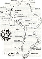
English: Diego Garcia Island Map, from around 2002. This is "FIGURE 2: Diego Garcia Island Map" from the source document, 'Local Area Forecaster's Handbook for Diego Garcia'. |
| Date | |
| Source | http://www.globalsecurity.org/military/library/report/2002/diego-fdo-handbook.doc (NAVCENTMETOCDETDGINST 3140.2 05 APR 2002) |
| Author | US Navy (Naval Central Meteorology and Oceanography Detachment, Diego Garcia) |
Licensing
This file is a work of a sailor or employee of the U.S. Navy, taken or made as part of that person's official duties. As a work of the U.S. federal government, it is in the public domain in the United States.
|
 | |
| This file has been identified as being free of known restrictions under copyright law, including all related and neighboring rights. | ||
File history
Click on a date/time to view the file as it appeared at that time.
| Date/Time | Thumbnail | Dimensions | User | Comment | |
|---|---|---|---|---|---|
| current | 21:17, 15 December 2014 | | 888 × 1,240 (203 KB) | commons>Rwendland | cropped |
File usage
There are no pages that use this file.