File:Dalmarnock railway station (geograph 2447289).jpg
Jump to navigation
Jump to search
No higher resolution available.
Dalmarnock_railway_station_(geograph_2447289).jpg (640 × 480 pixels, file size: 159 KB, MIME type: image/jpeg)
.jpg)
Summary
| Description |
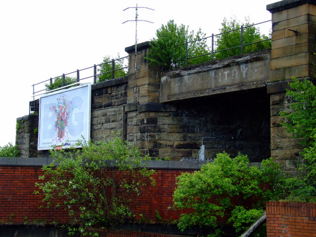
English: Dalmarnock railway station Dalmarnock is on the Argyle Line in the east end of Glasgow, between Bridgeton and Rutherglen stations. This area will be at the heart of the 2014 Commonwealth Games village and the station will receive a much needed make-over in preparation for that event. This is a view from the station of the former Caledonian Railway line where Dalmarnock High station once stood. |
| Date | |
| Source | From geograph.org.uk |
| Author | Thomas Nugent |
| Permission (Reusing this file) |
Creative Commons Attribution Share-alike license 2.0 |
| Attribution (required by the license) | Thomas Nugent / Dalmarnock railway station / |
| Camera location | | View this and other nearby images on: OpenStreetMap |
|---|
.jpg¶ms=055.842087_N_-004.217549_E_globe:Earth_type:camera_source:geograph-osgb36(NS61246321)_heading:45.00&language=en)
| Object location | | View this and other nearby images on: OpenStreetMap |
|---|
.jpg¶ms=055.842090_N_-004.217550_E_globe:Earth_class:object_type:object_source:geograph-osgb36(NS61246321)_heading:45.00&language=en)
Licensing

|
This image was taken from the Geograph project collection. See this photograph's page on the Geograph website for the photographer's contact details. The copyright on this image is owned by Thomas Nugent and is licensed for reuse under the Creative Commons Attribution-ShareAlike 2.0 license.
|
This file is licensed under the Creative Commons Attribution-Share Alike 2.0 Generic license.
Attribution: Thomas Nugent
- You are free:
- to share – to copy, distribute and transmit the work
- to remix – to adapt the work
- Under the following conditions:
- attribution – You must give appropriate credit, provide a link to the license, and indicate if changes were made. You may do so in any reasonable manner, but not in any way that suggests the licensor endorses you or your use.
- share alike – If you remix, transform, or build upon the material, you must distribute your contributions under the same or compatible license as the original.
File history
Click on a date/time to view the file as it appeared at that time.
| Date/Time | Thumbnail | Dimensions | User | Comment | |
|---|---|---|---|---|---|
| current | 06:56, 10 May 2020 | | 640 × 480 (159 KB) | commons>Crowsus | Transferred from geograph.co.uk using [https://tools.wmflabs.org/geograph2commons/ geograph2commons] |
File usage
There are no pages that use this file.
.jpg)