File:Centerville Lodge 371 F&AM.jpg
Jump to navigation
Jump to search

Size of this preview: 800 × 532 pixels. Other resolutions: 320 × 213 pixels | 640 × 426 pixels | 1,024 × 681 pixels | 1,280 × 851 pixels | 2,560 × 1,702 pixels | 6,016 × 4,000 pixels.
Original file (6,016 × 4,000 pixels, file size: 5.7 MB, MIME type: image/jpeg)
| Camera location | | View this and other nearby images on: OpenStreetMap |
|---|
| Description |
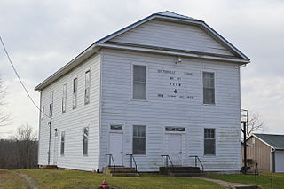
English: Front and eastern side of the Centerville Lodge 371 building, located at the intersection of State (State Route 279) and Vinton Streets in Centerville, Ohio, United States. |
||
| Date | Taken on 2 February 2016 | ||
| Source | Own work | ||
| Author | Nyttend | ||
| Permission (Reusing this file) |
|
File history
Click on a date/time to view the file as it appeared at that time.
| Date/Time | Thumbnail | Dimensions | User | Comment | |
|---|---|---|---|---|---|
| current | 15:41, 6 February 2016 | | 6,016 × 4,000 (5.7 MB) | commons>Nyttend | {{Location|38|53|52|N|82|26|45|W}} {{Information |Description={{en|Front and eastern side of the Centerville Lodge 371 building, located at the intersection of State ({{w|Ohio State Route 279|State Route 279}}) and Vinton Streets in {{w|Centerville, Ga... |
File usage
There are no pages that use this file.