File:Center of Europe - monument - nearby Rakhiv - Ukraine (5647-49).jpg
Jump to navigation
Jump to search

Size of this preview: 800 × 600 pixels. Other resolutions: 320 × 240 pixels | 640 × 480 pixels | 1,024 × 768 pixels | 1,280 × 960 pixels | 2,560 × 1,920 pixels | 3,200 × 2,400 pixels.
Original file (3,200 × 2,400 pixels, file size: 2.44 MB, MIME type: image/jpeg)
Summary
| Description |
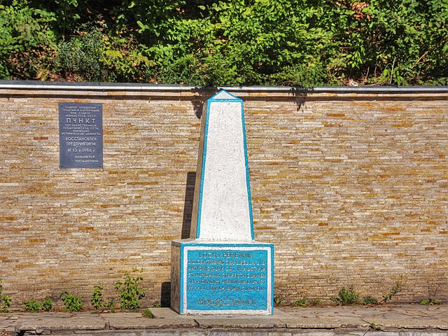
Українська: Географічний центр Європи, Круглий, Закарпатська область
Deutsch: Geographischer Mittelpunkt Europas bei Kruhlyj, Rajon Rachiw, Oblast Transkarpatien, Ukraine. Inschrift am Originalmonument von 1887: Locus perennis diligentissime cum libella librationis quae est in Austria et Hungaria confecta cum mensura gradum meridionalium et parallelorum Europe. MDCCCLXXXVII.
English: Geographical midpoint of Europe in Kruhlyy, Rakhiv Raion, Zakarpattia Oblast, Ukraine |
|||||||||||||||||
| Date | ||||||||||||||||||
| Source | Own work | |||||||||||||||||
| Author |
|
|||||||||||||||||
| Other versions |
|
|||||||||||||||||
| Attribution (required by the license) | © Raimond Spekking / | |||||||||||||||||

.jpg)
.jpg)
.jpg)
| Camera location | | View this and other nearby images on: OpenStreetMap |
|---|
.jpg¶ms=047.962843_N_0024.187541_E_globe:Earth_type:camera_alt:381_source:exif_heading:304.70&language=en)
Licensing
I have published this image as author under the Creative-Commons-Licence CC BY-SA 4.0.. This means that free online usage outside of Wikimedia projects under the following terms of licence is possible:
- The image is credited with "© Raimond Spekking / CC BY-SA 4.0 (via Wikimedia Commons)"
For all other kind of usages (books, journales, flyers, etc.) click on the following button. You will get all information needed.
.jpg)
I would be happy to receive a specimen copy or the URL of the website where the image is used.
Please write an email to raimond.spekking@gmail.com (GPG encrypted emails are welcome: Key-ID: 0xB12BE7A6), if you
- need the image in a higher resolution
- need my postal address for sending a specimen copy
- have further questions to the terms of licence
I, the copyright holder of this work, hereby publish it under the following license:
This file is licensed under the Creative Commons Attribution-Share Alike 4.0 International license.
Attribution: © Raimond Spekking / CC BY-SA 4.0 (via Wikimedia Commons)
- You are free:
- to share – to copy, distribute and transmit the work
- to remix – to adapt the work
- Under the following conditions:
- attribution – You must give appropriate credit, provide a link to the license, and indicate if changes were made. You may do so in any reasonable manner, but not in any way that suggests the licensor endorses you or your use.
- share alike – If you remix, transform, or build upon the material, you must distribute your contributions under the same or compatible license as the original.
File history
Click on a date/time to view the file as it appeared at that time.
| Date/Time | Thumbnail | Dimensions | User | Comment | |
|---|---|---|---|---|---|
| current | 16:30, 25 October 2016 | | 3,200 × 2,400 (2.44 MB) | commons>Bogomolov.PL | better contrast |
File usage
There are no pages that use this file.
.jpg)