File:Cairo Supper Club Building 4015-4017 North Sheridan Road Chicago 2020-3404.jpg
From WikiProjectMed
Jump to navigation
Jump to search
Size of this preview: 749 × 599 pixels. Other resolutions: 300 × 240 pixels | 600 × 480 pixels | 960 × 768 pixels | 1,280 × 1,024 pixels | 2,560 × 2,048 pixels | 4,967 × 3,974 pixels.
Original file (4,967 × 3,974 pixels, file size: 11.21 MB, MIME type: image/jpeg)
This file is from a shared repository and may be used by other projects. The description on its file description page there is shown below.
Summary
DescriptionCairo Supper Club Building 4015-4017 North Sheridan Road Chicago 2020-3404.jpg |
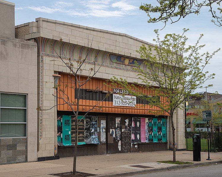
English: The Cairo Supper Club Building, a one-story, terra-cotta-clad building. 4015-4017 N. Sheridan Rd., Uptown, Chicago, Illinois. It is one of few Egyptian Revival-style buildings in Chicago. Architect: Paul Gerhardt, Sr. (1863–1951), Cook County Architect. The building operated as the Cairo Lounge, later the Cairo Supper Club, from 1949 to 1964, when it was firebombed. |
Date | |
Source | Own work |
Author | Paul R. Burley |
Camera location | 41° 57′ 18.66″ N, 87° 39′ 16.59″ W | View this and other nearby images on: OpenStreetMap | 41.955182; -87.654608 |
---|
Licensing
I, the copyright holder of this work, hereby publish it under the following license:
This file is licensed under the Creative Commons Attribution-Share Alike 4.0 International license.
- You are free:
- to share – to copy, distribute and transmit the work
- to remix – to adapt the work
- Under the following conditions:
- attribution – You must give appropriate credit, provide a link to the license, and indicate if changes were made. You may do so in any reasonable manner, but not in any way that suggests the licensor endorses you or your use.
- share alike – If you remix, transform, or build upon the material, you must distribute your contributions under the same or compatible license as the original.
Items portrayed in this file
depicts
some value
23 May 2020
41°57'18.655"N, 87°39'16.589"W
0.003125 second
7.1
50 millimetre
100
image/jpeg
ce183530b7765912abf1e1bb9f29931c408b1e1c
11,753,516 byte
3,974 pixel
4,967 pixel
File history
Click on a date/time to view the file as it appeared at that time.
Date/Time | Thumbnail | Dimensions | User | Comment | |
---|---|---|---|---|---|
current | 03:10, 24 May 2020 | 4,967 × 3,974 (11.21 MB) | commons>Prburley | Uploaded own work with UploadWizard |
File usage
There are no pages that use this file.
Metadata
This file contains additional information, probably added from the digital camera or scanner used to create or digitize it.
If the file has been modified from its original state, some details may not fully reflect the modified file.
Camera manufacturer | Canon |
---|---|
Camera model | Canon EOS 6D Mark II |
Author | Paul R. Burley |
Exposure time | 1/320 sec (0.003125) |
F Number | f/7.1 |
ISO speed rating | 100 |
Date and time of data generation | 13:22, 23 May 2020 |
Lens focal length | 50 mm |
Latitude | 41° 57′ 18.65″ N |
Longitude | 87° 39′ 16.59″ W |
Altitude | 198.9 meters above sea level |
Label | Red |
City shown | Chicago |
Width | 4,967 px |
Height | 3,974 px |
Bits per component |
|
Pixel composition | RGB |
Orientation | Normal |
Number of components | 3 |
Horizontal resolution | 240 dpi |
Vertical resolution | 240 dpi |
Software used | Adobe Photoshop 21.0 (Windows) |
File change date and time | 21:55, 23 May 2020 |
Exposure Program | Normal program |
Exif version | 2.31 |
Date and time of digitizing | 13:22, 23 May 2020 |
APEX shutter speed | 8.321928 |
APEX aperture | 5.655638 |
APEX exposure bias | 0 |
Maximum land aperture | 4 APEX (f/4) |
Metering mode | Pattern |
Flash | Flash did not fire, compulsory flash suppression |
DateTimeOriginal subseconds | 48 |
DateTimeDigitized subseconds | 48 |
Color space | sRGB |
Focal plane X resolution | 1,736.671661377 |
Focal plane Y resolution | 1,736.671661377 |
Focal plane resolution unit | 3 |
Custom image processing | Normal process |
Exposure mode | Auto exposure |
White balance | Auto white balance |
Scene capture type | Standard |
GPS time (atomic clock) | 19:22:1.043 |
Satellites used for measurement | 7 |
Receiver status | Measurement in progress |
Measurement mode | 3-dimensional measurement |
Measurement precision | Good (2.6) |
Geodetic survey data used | WGS-84 |
GPS date | 23 May 2020 |
GPS tag version | 0.0.3.2 |
Serial number of camera | 252052000492 |
Lens used | EF24-105mm f/4L IS II USM |
Date metadata was last modified | 16:55, 23 May 2020 |
Unique ID of original document | 90716AE96AFF196176D734EF659154BB |
Copyright status | Copyright status not set |
Province or state shown | Illinois |
Country shown | United States |
Code for country shown | US |
Sublocation of city shown | Buena Park |
IIM version | 4 |