File:C74112s5 Ant.Map Martin Peninsula.jpg
Jump to navigation
Jump to search

Size of this preview: 581 × 599 pixels. Other resolutions: 233 × 240 pixels | 465 × 480 pixels | 745 × 768 pixels | 993 × 1,024 pixels | 1,985 × 2,048 pixels | 3,621 × 3,735 pixels.
Original file (3,621 × 3,735 pixels, file size: 1.52 MB, MIME type: image/jpeg)
Summary
| Description |
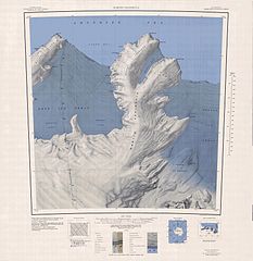
English: 1:250,000-scale topographic reconnaissance map of the Martin Peninsula area from 112°30'-117°W to 73°45'-75°S in Antarctica, including the eastern parts of the Getz Ice Shelf and the western parts of Dotson Ice Shelf. Mapped, edited and published by the U.S. Geological Survey in cooperation with the National Science Foundation. |
|||
| Date | ||||
| Source | http://usarc.usgs.gov/drg_dload.shtml | |||
| Author | United States Geological Survey | |||
| Permission (Reusing this file) |
|
File history
Click on a date/time to view the file as it appeared at that time.
| Date/Time | Thumbnail | Dimensions | User | Comment | |
|---|---|---|---|---|---|
| current | 06:31, 4 April 2005 | | 3,621 × 3,735 (1.52 MB) | commons>Achim Raschka | Map of Antarctica by the United States Antarctic Ressource Center of the US Geological Society. {{PD-US}} Copyrights and Trademarks USGS-authored or produced data and information are in the public domain. While the content of most USGS web pages is in th |
File usage
There are no pages that use this file.