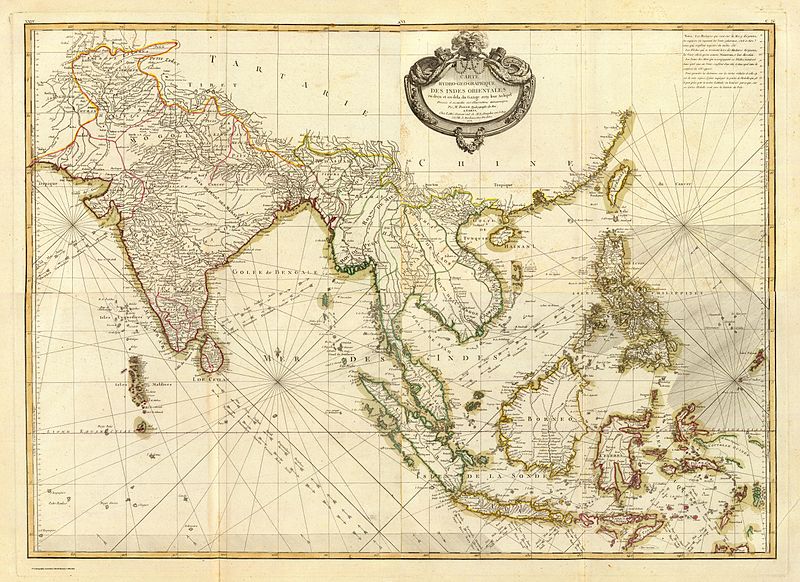
File:Bonne - Carte hydro-geo-graphique des Indes Orientales.jpg
Jump to navigation
Jump to search

Size of this preview: 800 × 582 pixels. Other resolutions: 320 × 233 pixels | 640 × 465 pixels | 1,024 × 745 pixels | 1,280 × 931 pixels | 2,560 × 1,861 pixels | 10,451 × 7,599 pixels.
Original file (10,451 × 7,599 pixels, file size: 15.59 MB, MIME type: image/jpeg)
File history
Click on a date/time to view the file as it appeared at that time.
| Date/Time | Thumbnail | Dimensions | User | Comment | |
|---|---|---|---|---|---|
| current | 22:22, 22 February 2007 | | 10,451 × 7,599 (15.59 MB) | commons>Frank Schulenburg | Rigobert Bonne (1727–1794), ''Carte hydro-geo-graphique des Indes Orientales en deca et au dela du Gange avec leur archipel …'', Paris 1771 * Type: Composite Map * Original: 59 x 81 cm * Published in: Atlas moderne ou collection de cartes sur toutes |
File usage
There are no pages that use this file.