File:Barking and Dagenham UK local election 2010 map.svg
Jump to navigation
Jump to search

Size of this PNG preview of this SVG file: 525 × 600 pixels. Other resolutions: 210 × 240 pixels | 420 × 480 pixels | 672 × 768 pixels | 896 × 1,024 pixels | 1,792 × 2,048 pixels | 1,108 × 1,266 pixels.
Original file (SVG file, nominally 1,108 × 1,266 pixels, file size: 471 KB)
File history
Click on a date/time to view the file as it appeared at that time.
| Date/Time | Thumbnail | Dimensions | User | Comment | |
|---|---|---|---|---|---|
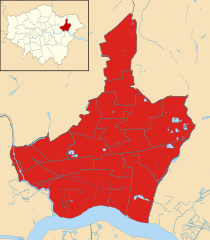
| current | 18:02, 29 July 2011 | | 1,108 × 1,266 (471 KB) | commons>Davewild | {{Information |Description=Map of London Borough of Barking and Dagenham, UK showing the results of the 2010 local election. Colour: {{legend|#dc241f|Labour}} |Source=*File:Barking_and_Dagenham_London_UK_blank_ward_map.svg |Date=2011-07-29 18:01 (U |
File usage
There are no pages that use this file.