File:Baltoro region from space annotated.png
Jump to navigation
Jump to search

Size of this preview: 633 × 600 pixels. Other resolutions: 253 × 240 pixels | 507 × 480 pixels | 811 × 768 pixels | 1,081 × 1,024 pixels | 2,336 × 2,213 pixels.
Original file (2,336 × 2,213 pixels, file size: 9.84 MB, MIME type: image/png)
File history
Click on a date/time to view the file as it appeared at that time.
| Date/Time | Thumbnail | Dimensions | User | Comment | |
|---|---|---|---|---|---|
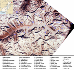
| current | 15:56, 21 November 2008 | | 2,336 × 2,213 (9.84 MB) | commons>Rupert Pupkin | {{Information |Description={{en|1=Baltoro region from space. Many mountains (e.g. K2, Broad Peak, Gasherbrums, Trango Towers) and glaciers are marked. |Source=*Image:Pk-map.png |Date=2008-11-21 15:50 (UTC) |Author=*derivative work: ~~~ *[[:Image:Pk- |
File usage
There are no pages that use this file.