File:Arrowsmith Map of Texas 1841 UTA.jpg
Jump to navigation
Jump to search

Size of this preview: 493 × 600 pixels. Other resolutions: 197 × 240 pixels | 394 × 480 pixels | 631 × 768 pixels | 842 × 1,024 pixels | 1,683 × 2,048 pixels | 12,300 × 14,963 pixels.
Original file (12,300 × 14,963 pixels, file size: 83.62 MB, MIME type: image/jpeg)
File history
Click on a date/time to view the file as it appeared at that time.
| Date/Time | Thumbnail | Dimensions | User | Comment | |
|---|---|---|---|---|---|
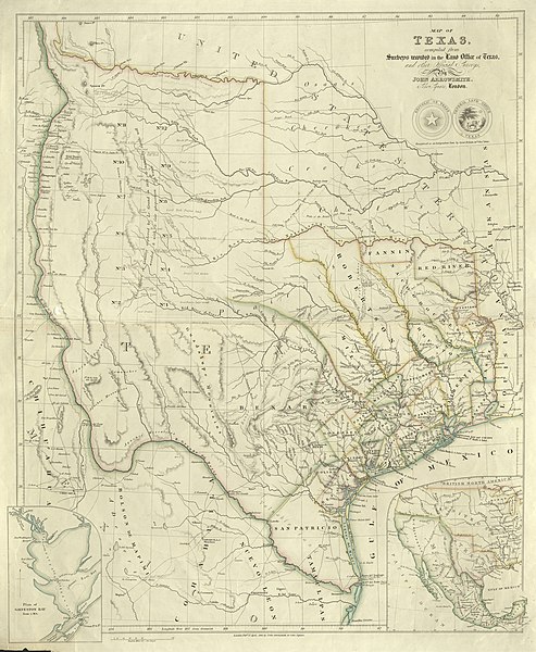
| current | 14:36, 10 August 2019 | | 12,300 × 14,963 (83.62 MB) | commons>Michael Barera | == {{int:filedesc}} == {{Map |title = ''Map of Texas compiled from Surveys recorded in the Land Office of Texas and other official Surveys'' |description = {{en|John Arrowsmith's 1841 map of Texas was one of the first maps to show the new republic's most ambitious boundaries. These included the lower Rio Grande and not the Nueces River as the southern boundary with Mexico, the upper Rio Grande as the border with Mexican New Mexico, and the "stovepipe" panhandle stretching... |
File usage
There are no pages that use this file.