File:1987 Edmonton Tornado path.png
Jump to navigation
Jump to search
Size of this preview: 650 × 599 pixels. Other resolutions: 260 × 240 pixels | 521 × 480 pixels | 678 × 625 pixels.
Original file (678 × 625 pixels, file size: 176 KB, MIME type: image/png)
Summary
| Description |
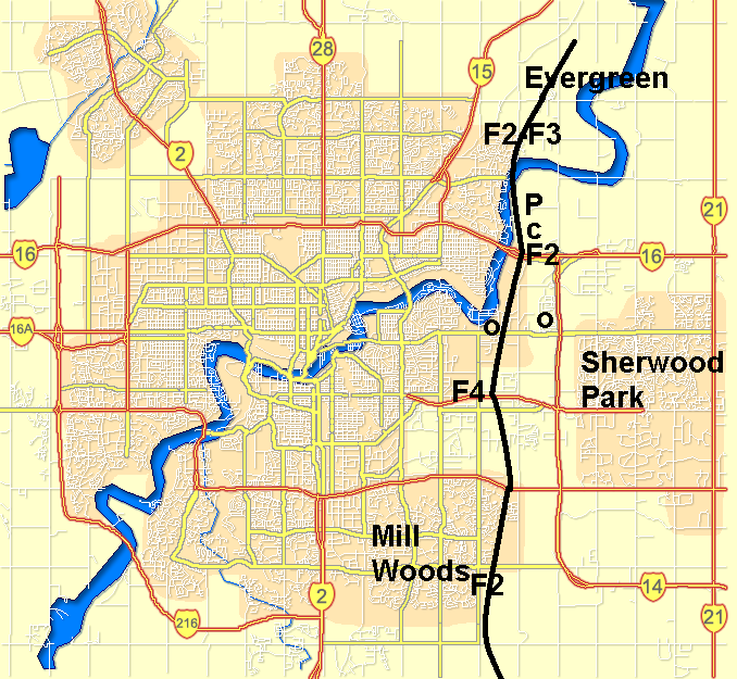
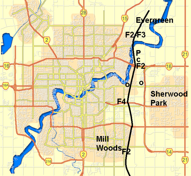
English: Path taken by the F4 Edmonton tornado in 1987. The F numbers are for the Fujita values, the O is for Imperial Oil Strathcona and Petro-Canada refineries, P is the Edmonton Power Clover power station and C is for the Celanese Canada chemical plant. The image is made using File:Edmonton_street_map.png as the background and data from University of Alberta Atlas of the Edmonton Tornado and Halstorm.
Français : Carte d'Edmonton sur laquelle le trajet de la tornade de 1987 est montré. Les F# rerpésentent les valeur de Fujita, O les deux raffineries de Imperial Oil Strathcona et Petro-Canada, P est la centrale électrique de Clover et C est pour l'usine pétrochimique de Celanese Canada. L'image est faite avec comme fond File:Edmonton_street_map.png et les données de University of Alberta Atlas of the Edmonton Tornado and Halstorm. |
| Date | |
| Source | Own work |
| Author | Pierre cb |
Licensing
| I, the copyright holder of this work, release this work into the public domain. This applies worldwide. In some countries this may not be legally possible; if so: I grant anyone the right to use this work for any purpose, without any conditions, unless such conditions are required by law. |
File history
Click on a date/time to view the file as it appeared at that time.
| Date/Time | Thumbnail | Dimensions | User | Comment | |
|---|---|---|---|---|---|
| current | 04:31, 5 July 2010 | | 678 × 625 (176 KB) | commons>Pierre cb | {{Information |Description={{en|1=Path taken by the F4 Edmonton tornado in 1987. The F numbers are for the Fujita values, the O is for Imperial Oil Strathcona and Petro-Canada refineries, P is the Edmonton Power Clover power station and C is for the Celan |
File usage
There are no pages that use this file.