File:衆議院小選挙区 埼玉県.svg

Original file (SVG file, nominally 628 × 360 pixels, file size: 67 KB)
Summary

|
This file may be updated to reflect new information. If you wish to use a specific version of the file without new updates being mirrored, please upload the required version as a separate file. |
| Description |
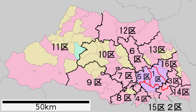
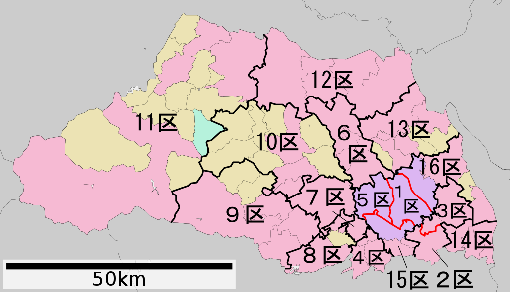
日本語: 衆議院議員小選挙区の埼玉県における区割り。黒線=地方公共団体間の境界線上にある境界。 赤線=同一地方公共団体内にある境界。 水色線=海上または湖沼上での境界。 |
||
| Date | |||
| Source | File:包括自治体区画図 11000.svg(アップロード者はLincun)を元に作成。 | ||
| Author | 猿払の天馬 | ||
| Permission (Reusing this file) |
|
Licensing

|
Permission is granted to copy, distribute and/or modify this document under the terms of the GNU Free Documentation License, Version 1.2 or any later version published by the Free Software Foundation; with no Invariant Sections, no Front-Cover Texts, and no Back-Cover Texts. A copy of the license is included in the section entitled GNU Free Documentation License. |
- You are free:
- to share – to copy, distribute and transmit the work
- to remix – to adapt the work
- Under the following conditions:
- attribution – You must give appropriate credit, provide a link to the license, and indicate if changes were made. You may do so in any reasonable manner, but not in any way that suggests the licensor endorses you or your use.
Original upload log
| Date/Time | Dimensions | User | Comment |
|---|---|---|---|
| 2017-07-17 13:42 | 628×360× (61503 bytes) | そらみみ | 更新 |
| 2017-05-21 18:05 | 628×360× (62563 bytes) | そらみみ | 細部修正 |
| 2017-05-21 10:36 | 628×360× (61818 bytes) | そらみみ | 細部修正 |
| 2013-02-10 13:59 | 628×360× (62222 bytes) | 猿払の天馬 | {{Information |Description=衆議院議員小選挙区の埼玉県における区割り。黒線=地方公共団体間の境界線上にある境界。 赤線=同一地方公共団体内にある境界。 水色線=海上での境界。 |Source=[[:フ... |
| This file was moved from Japanese Wikipedia.
See below for original file information. | ||||||||||||||||||||||||||||||||||||||||||||||||||||
| ||||||||||||||||||||||||||||||||||||||||||||||||||||
|
| ||||||||||||||||||||||||||||||||||||||||||||||||||||
File history
Click on a date/time to view the file as it appeared at that time.
| Date/Time | Thumbnail | Dimensions | User | Comment | |
|---|---|---|---|---|---|
| current | 18:17, 4 January 2023 | | 628 × 360 (67 KB) | commons>そらみみ | 更新 |
File usage
There are no pages that use this file.