Abbotts Creek (North Carolina)
| Abbotts Creek Tributary to Yadkin River | |
|---|---|
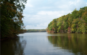
 Abbotts Creek section of High Rock Lake North Carolina | |
 Location of Abbotts Creek mouth | |
| Location | |
| Country | United States |
| State | North Carolina |
| Counties | Davidson Forsyth |
| Physical characteristics | |
| Source | divide between Abbotts Creek and Belews Creek (Dan River tributary) |
| • location | Kernersville, North Carolina[2] |
| • coordinates | 36°07′06″N 080°04′15″W / 36.11833°N 80.07083°W[1] |
| • elevation | 1,000 ft (300 m)[3] |
| Mouth | Yadkin River (High Rock Lake) |
• location | High Rock Lake[2] |
• coordinates | 35°37′43″N 080°15′48″W / 35.62861°N 80.26333°W[1] |
• elevation | 624 ft (190 m)[3] |
| Length | 45.45 mi (73.14 km)[4] |
| Basin size | 223.6 square miles (579 km2)[5] |
| Discharge | |
| • location | High Rock Lake (Yadkin River) |
| • average | 220.54 cu ft/s (6.245 m3/s) at mouth with High Rock Lake[6] |
| Basin features | |
| Progression | generally south |
| River system | Yadkin River |
| Tributaries | |
| • left | Cuddybum Branch Rich Fork Pounder Fork Buddle Branch |
| • right | Spurgeon Creek Reedy Run Brushy Fork Leonard Creek |
| Waterbodies | Lake Thom-A-Lex High Rock Lake |
Abbotts Creek starts in Kernersville, NC in Forsyth County and flows into High Rock Lake near Lexington, NC in Davidson County just north of Hwy 47. The section of High Rock Lake that is officially Abbotts Creeks ends near the Hwy 8 causeway, in Southmont, NC.
The median flow at Lexington ranges from 50 to 200 cubic feet per second.[7] While it only provides a relatively small amount of water that enters the lake, it provides a significant fraction of the total surface area of the lake and hosts a large community of lake front homes, as well as provides significant habitat for fish and wildlife. The upper sections of the lake at Abbotts Creek do not have lake front properties and are considered prime area for sports fishing, particularly largemouth bass and catfish.
The lake, up to the high water mark is under the control of Alcoa and is managed under contract granted by the US government.
Gallery
-
 Large composite panoramic image of Abbotts Creek from Hwy 8
 -
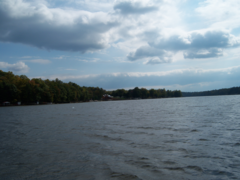
 View of Abbotts Creek where it becomes High Rock Lake, from Hwy 47.
 -
 Cove along the north end of Abbotts Creek
 -
 Main channel in northern end of Abbotts Creek


See also
Maps
.gif)
.gif)
References
- ^ a b "GNIS Detail - Abbotts Creek". geonames.usgs.gov. US Geological Survey. Retrieved 23 July 2019.
- ^ a b "Abbotts Creek Topo Map, Davidson County NC (Southmont Area)". TopoZone. Locality, LLC. Retrieved 23 July 2019.
- ^ a b "Abbotts Creek Topo Map, Davidson County NC (Southmont Area)". TopoZone. Locality, LLC. Retrieved 31 July 2019.
- ^ "ArcGIS Web Application". epa.maps.arcgis.com. US EPA. Retrieved 23 July 2019.
- ^ "Abbotts Creek Watershed Report". Waters Geoviewer. US EPA. Retrieved 31 July 2019.
- ^ "Abbotts Creek Watershed Report". Waters Geoviewer. US EPA. Retrieved 23 July 2019.
- ^ USGS Real-Time Water Data for USGS 02121500 ABBOTTS CREEK AT LEXINGTON, NC
External links
- Historical average discharges
- Alcoa - Current Official Conditions at High Rock Lake
- High Rock Lake Association
- High-Rock.com A collection of links, images, travel and directory info for the area
- High Rock River Rats
- SaveHighRockLake.org
| Authority control databases: National |
|---|